Canada Land Inventory (CLI) capability with relief enhancement gives a Google Earth like visual display of one of Canada's most comprehensive knowledge bases. This digital map was prepared by Glenn W. Lelyk, specialist in Land resource applications in the Land Resource Unit- Manitoba of Agriculture and Agri-Food Canada, University of Manitoba Campus, Winnipeg, Manitoba.
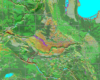
The agricultural capability classification from the 1:250'000 CLI is superimposed on a digital terrain model. The shaded relief enhances the relationships between the capability classification and the geomorphology , soils and glacial and post glacial history. The warm coloured hart of the map is formed by the glacial delta of the Assiniboine river. The former glacial lake beaches, starting at the slopes of Riding Mountain National Park in the top-middle of the map image, diagonally devide the right half of the map: The glacial lake plain with lacustrine clay deposits on the east side, and a predominance of ground moraine material on the west side.
When combined with Google Earth, the CLI"knowledge" map becomes particularly powerful as visualization of the potential of landscape ecosystems as building blocks for integrated regional planning and management. It enables broader public understanding and participation in public policy and resource management, especially for resource dependent communities.


The Canada Land Inventory was actually designed for this purpose in the late 1960's and implemented in the 1967-1977 period. The sheer size of this Federal-Provincial Inventory Program required the development and of the Canadian Geographic Information System (CGIS) the first operational GIS in the world, designed for regional planning as well as continental wide analysis.


The Canada Land Inventory System covers about 2.5 million km2 of Canada's settled lands. Digital files can be obtained from Natural Resources Canada: http://geogratis.cgdi.gc.ca/CLI/frames.html
![[+ larger version of Map]](images6/ag_cap_srtm2-2000.jpg)