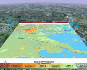
A Multi-disciplinary survey of land and water resources: The Canada Land Inventory provides one of the most comprehensive digital map sources for resource planning ad management in Canada. The area covered by the CLI is indicated in the index map. For each of the map sheets areas land capability is mapped at 1:250'000 scale and usually at a 1:50'000 scale. This is an example for Map sheet 63F, The Pas, in Manitoba. The index map on the right shows the areas map for forest capability under the CLI. The left image shows an example of a number of overlays displayed on Google Earth
 |
 |
Each of the 1.250'000 scale maps has an extensive description of the landscape ecosystem and capability perspectives. Below is an example for The Pas map sheet.
GENERAL DESCRIPTION OF
THE PAS MAP SHEET AREA, 63F
INTRODUCTION
CLIMATE
SOILS AND AGRICULTURAL CAPABILITY
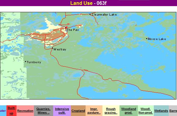
SETTLEMENT AND LAND USE
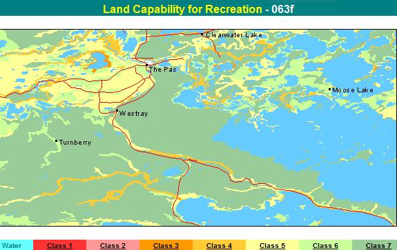
RECREATION POTENTIAL
UNGULATE ECOLOGY
LAND CAPABILITY FOR UNGULATES
WATERFOWL ECOLOGY
LAND CLASSIFICATION FOR FORESTRY
INTRODUCTION
The area covered The Pas map sheet comprises about 5700 square miles between
53M0 and 54 north latitude and 1000 and 102 west longitude. Settlement in
the area is sparse. The Pas, which has a population of 5031 (1966 census),
is the center of the fur trade, tourist, agricultural, and forestry industries
of the area.
Parts of the Moose and Cedar lakes and Lake Winnipegosis dominate the eastern
portion of the area. Many smaller lakes and marshes dot the broad Saskatchewan
River delta, which stretches from Moose Lake into Saskatchewan. The delta is
bisected from north to south by a prominent terminal moraine, The Pas moraine.
From the delta, the moraine arcs southeastward, separating Cedar Lake from
Lake Winnipegosis. West of these lakes and south of the delta are extensive
lake-modified till plains.
The area is located in the Manitoba Lowland physiographic region and has two distinct physiographic sections: the Saskatchewan River delta and the Interlake Westlake Till Plain. The delta is flat to slightly undulating with micro relief caused by stream braiding and channel shifting. Gentle ridge and swale topography, with northwest-to-southeast orientation, is the most outstanding geographic feature of the Interlake - Westlake Till Plain. Elevations range from 830 feet above sea level near Lake Winnipegosis to 1062 feet near Niska Creek on the westem edge of the area. The only significant relief occurs along the west side of The Pas moraine and on some lake shores in the northeast.
The area is underlain by sedimentary bedrocks, mainly sands, sandstones, and shales in the southwest and dolomites and dolomite-limestone mixtures in the rest of the area. The bedrock is covered by three types of surficial deposits: till, lacustrine sediments and alluvium. Shallow ground moraine was deposited when the last continental glacier retreated. The Pas moraine developed when the ice sheet was fairly stationary. Melt water from the receding glacier formed Lake Agassiz, which molded the till and deposited fine lacustrine sediments Alluvium was laid down by the forerunners of streams such as the Saskatchewan and Overflowing rivers.
Periodic floods deposit additional alluvium on the Saskatchewan River delta. These silty clay deposits have little profile development but are very fertile, except where they contain an excess of soluble salts or are poorly drained. Topsoil development over the rest of the area is slow and is strongly influenced by consistently high levels of soil moisture. Forest on the till plain has degraded the calcareous till lacustrine parent material. This soil is generally shallow, seldom well drained,and lacks fertility. Organic accumulations occupy extensive poorly drained depressions, mainly in the southern third of the area.
The area has two drainage basins. The Overflowing River system, Swamp Creek and several smaller streams drain the south-central part of the area into Lake Winnipegosis. The rest of the area drains to Cedar Lake through the streams and channels of the Saskatchewan River delta. West of The Pas, the main tributaries of the Saskatchewan are the Pasquia and Carrot rivers. East of The Pas, many creeks join the Saskatchewan River, which divides into several well-developed channels as it nears Cedar Lake.
CLIMATE
The climate of the area is continental sub humid, characterized by warm, short
summers and very cold, long winters. The average yearly precipitation at The
Pas is 17 inches about three-quarters of which falls as rain during the growing
season. The mean annual temperature, based on records of more than 40 years
at The Pas, is 320 F. July, the warmest month has a mean monthly temperature
of 650 F, and January, the coldest month, has a mean monthly temperature of
-5 F.
The mean date of the last spring frost occurs on May 31, but varies from May 7 to July 12, whereas the mean date of the first fall frost occurs on September 9, and varies from August 8 to October 11. The area has a growing season of 154 to 165 days and an average of 100 frost-free days a year.
The short growing season (2000 to 2250 degree-days) is offset to some extent by the longer photoperiod in northern latitudes. This is reflected in the rapid growth of hay and pasture crops and the rapid development and delayed maturity of cereal crops in the area.
Low-lying regions have a shorter frost-free period, but they generally have a longer growing season than more elevated regions. This is partly because of the high humidity. The humidity often results in fog formation and cloud cover in the fall MI the Saskatchewan Delta and the southern fringe of Cedar Lake.
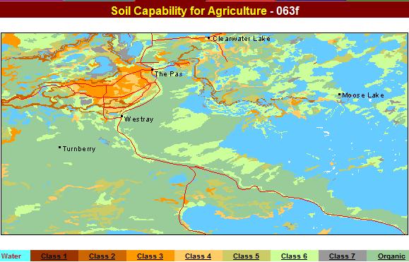
SOILS AND AGRICULTURAL CAPABILITY
The soils of the area are within two climatically significant zones. Zone II,
characterized by Chernozemic-Brunisolic soils comprises the Saskatchewan Delta
and a small part of the extreme southwest. Organic, Gleysolic, and Regosolic
soils predominate in this zone. The rest of the area is within Zone III, a
BrunisolicLuvisolic-Organic zone, whose upper boundary is directly north of
The Pas area. Climatic conditions in this zone vary from mild in the southem
part of the area to severe in the northem part. The dominant soils in Zone
III are Organic, Luvisolic, and Brunisolic soils.
Organic soils comprise about 40 percent of the area. Fibrisols and Mesisols are dominant and have developed from forest, sphagnum, and fan deposits. Fibrisols, developed from sphagnum peat, consist mainly of relatively undecomposed organic material. Mesisols are in an intermediate stage of decomposition. The organic material of Mesisols in the area is either fan or forest peat or a combination of these. Organic soils are denoted as Class O for agricultural capability.
Gleysolic soils comprise about 10 percent of the area. These soils are saturated with water for part or all of the year, unless they are artificially drained. Gleysols are the dominant Gleysolic soils in the area. They are characterized by a very thin, dark, surface mineral horizon high in organic matter, which is usually overlain by less than 16 inches of fan or forest peat. Gleysols have developed on all parent materials in the area. They occur throughout the Saskatchewan Delta, where they are associated with forest vegetation and usually have a thin layer of sphagnum peat in the upper part of their profile. Agricultural capability for Gleysols in the area ranges from Classes 3 to Class 6, with the main limitation being wetness. Sites rated Classes 3 and 4 usually reflect man-made improvements in drainage.
Regosolic soils comprise less than 5 percent of the area. Only the Regosol Great Group has been identified to date. Regosols are well and imperfectly drained soils that have little or no horizon development. Regosols in the area occur mainly in the Saskatchewan Delta along stream channels and are dominantly imperfectly drained. They are usually light colored and have developed on fine sandy loam to clay textured, moderately calcareous sediments with a high productivity potential. Agricultural capabilities range from Classes 2 to 4, with the main limitations being wetness poor structure, and salinity.
Brunisolic soils comprise about 10 percent of the area; Eutric Brunisols are dominant. These are well to imperfectly drained soils that have organic surface horizons underlain by a thin leached horizon and a brownish mellowed horizon. Eutric Brunisols predominate on extremely calcareous, stony, medium textured glacial till deposits. These soils range from Classes 3 to Class 6 in agricultural capability, and are mainly limited by stoniness and wetness.
Luvisolic soils occur in less than 3 percent of the area. These well to imperfectly ) drained Gray Luvisols are characterized by organic surface horizons light-colored eluvial horizons, and brownish illuvial horizons in which clay is the main accumulation product. Gray Luvisols are found on the thick, fine-textured, moderately calcareous till deposits throughout the area and also occur as minor associates of the Eutric Brunisols on the medium textured, high-lime tills. The agricultural capability of the Gray Luvisols in the area ranges from Classes 3 to 6. The main limitations are drainage, stoniness and poor structure.
SETTLEMENT AND LAND USE
In the north. people settled in localities that provided opportunities for
trapping and fishing. The strategic location of the town of The Pas on the
Saskatchewan River enhanced its importance as a gateway to the northwest during
the days of the fur trade. The Pasquia region has been known since 1691, when
the Saskatchewan River was a main artery of travel during the fur trade era.
During the Hudson's Bay Company rule (1670 to 1870), interest in this land
was restricted to its fur potential. Some grain and garden crops were grown
around the forts and church missions.
Interest in land reclamation began about 1900. Before then, 1000 acres of higher land along the Carrot and Pasquia rivers had been subdivided and patented as river lots. The construction of the Canadian National Railway in 1908 stimulated agricultural development. As a result, the government began to study the reclamation possibilities of the Pasquia region of the Upper Saskatchewan Delta.
The Carrot River serves as a natural boundary between the cultivated part of the area which comprises about 142,700 acres, and the relatively unaltered deltaic region. The cultivated Pasquia region, which was reclaimed in 1961, is located south of this river and is bounded on the south by the Pasquia River. The relatively unaltered region north of the Carrot River is known as the Saskeram and is presently being used for wildlife management, forage production, and livestock grazing.
Within the area, a combination of climate and land development problems significantly restrict agriculture. Before inundation by Cedar Lake, the possibilities of agricultural development of 360,000 acres in the Lower Saskatchewan Delta were studied. However, Rahls Island, which comprises about 7000 acres east of The Pas, is the only other reclaimed arable land.
The Pas has become a trading center for the Pasquia and Rahls Island farming settlements which are significant as the largest northern farming settlements in Manitoba. The recently constructed forestry complex at The Pas has resulted in an influx of people and has also provided employment for many of the native people.
The Canadian National Railway links The Pas with the northern communities of Flin Flon, Snow Lake, Lynn Lake, Thompson, and Churchill. Highway No. 10 links The Pas with mining areas in the north and with the farming communities of Swan River and Dauphin to the south. A secondary road west of The Pas extends through the Pasquia settlement and joins Saskatchewan Provincial Road No. 109. About 18 miles north of Overflowing River, a hydro access trail branches off Highway No. 10 and runs southeast along The Pas moraine to join Highway No. 6 to Grand Rapids. The airfield at Guy Hill and the float plane base at Grace Lake provide air service to remote communities in northem Manitoba.
Potential for agriculture is confined mainly to the Saskatchewan Delta. The main factor limiting agricultural development throughout the area is the lack of adequate drainage. Outside the Saskatchewan Delta, good agricultural land occurs in such small units that even grazing would be impractical. A moderately adverse climate is a further limitation to the development of these soils. The largest continuous acreages of high-capability agricultural land occur in the Pasquia and Rahls Island settlements. Therefore, agricultural reclamation should be limited to these regions. Inundation of the Lower Saskatchewan Delta by the Cedar Lake Reservoir as well as the discontinuous distribution of good farmland along the river levees makes future large-scale reclamation projects unfeasible.
In their natural environment, Organic and Brunisolic soils are not suitable for agriculture because of wetness and stoniness respectively. Gleysols in the delta can be improved to Class 3, however, wetness remains a limitation. Forage crops would probably be best suited to these soils.
Regosols are stone-free and ideal for vegetable, root, and hay crops. In general, these soils occur on sites that require diking and drainage to protect them from seasonal flooding. The largest regions of these soils that have been reclaimed in Manitoba are found in the Pasquia region and on Rahls Island. Luvisols are well suited to the production of grasses and legumes and could support coarse grains if adequately fertilized.
In the Saskatchewan Delta, where drainage has been improved, mixed farming stock raising enterprises are common. Late spring plantings and subsequent late fall harvests as well as high production costs and low retums per acre have resulted in very poor net incomes for grain farmers. Farm labor costs are high because of competition with altemate job opportunities in the area. Consequently, owners of small and medium-sized farms have turned to off-farm employment to subsidize their farm incomes. The high incidence of nonresident landowners has resulted in only partial utilization of farm potential. Even on highly capitalized units where many operators are farming full time, there is a poor return on investment.
The Pasquia and Rahls Island settlements have a total of 146 farmers. Rapeseed, hay, wheat, barley, flax, and oats are the main crops, however, summer fallow occupies the greatest single acreage. Total livestock on farms are about 2600 beef cattle, 510 dairy cattle, 1700 hogs, and 265 sheep. There are about 4700 laying hens and a commercial flock of 12000 birds.
Improved drainage may decrease crop losses but the short growing season and the adverse effect of high fall precipitation will continue to limit grain farming. Mixed fanning, dairying, and root crop production offer the greatest potential for the Delta region, particularly because of the proximity of the region to rapidly expanding mining communities such as Flin Flon, Thompson, and Lynn Lake.
Capability classification by B. T. Heal, Manitoba Department of Mines, Resources and Environmental Management, and K. W. Ayres, Canada Department of Agriculture, 1969.
Description by B. T. Heal and G. C. Jenkins Manitoba Department of Mines Resources and Environmental Management and Dr. G. J. Bake and K. W.Ayres Canada Department of Agriculture 1969.
Fertile, well-drained sites support thrifty mixed woods. The largest mixed woods are east of the lower Saskatchewan River delta. Other significant stands occur mainly as narrow bands along well-developed river channels and on the north shore of Lake Winnipegosis.
The main tree species of the mixed woods are white spruce (Picea glauca), aspen poplar (Populus tremuloides), and balsam poplar (P. balsamifera), sometimes mixed with balsam fir (Abies balsamea) and white birch (Betula papyrifera). The vigorous understory includes mountain maple (Acer spicatum), bush-cranberries (Viburnum spp.), alders (Alnus spp.), willows (Saliw spp.), red-osier (Cornus stolonifera), roses (Rosa spp.), snowberries (Symphoricarpos spp.). saskatoon (Amelanchier alnifolia), pin cherry (Prunus pensylvanica), and saplings of the overstory species. American elm (Ulmus americana), ash (Frarinus pensylvanica var. austini), and Manitoba maple (Acer negundo) are found in scattered locations and reach their northern limit in Manitoba, along the banks of the Saskatchewan River. Similarly, mountain maple, hawthorn (Crataegus socculenta), beaked hazel (Corylus cornuta), ground-cherry (Physalis sp.), and red-fruited choke cherry (Prunus virginiana) are near the northern limit of their distribution in Manitoba, in this region.
The deltaic plain is characterized by meandering streams, moist plains, and numerous shallow water bodies and supports a wide variety of vegetation. On levees and till hillocks, moisture-tolerant shrub associations occur. Dominant shrubs are alders and willows, with red-osier dogwood and high bush-cranberry (Viburnum trilobum) as secondary species. Lower on the moist plains, there is a progression from low willow - sedge (Carer spp.) fans, through sedge fens, to common reed grass (Phragmites communis) bordering the water bodies. Feat appears in the soil profile throughout much of the delta. Basins filled with peat have a tree cover of black spruce (Picea mariana) in association with tamarack (Larix laricina). Understory species include swamp birches (Betula spp.), willows, and sweet gale (Myrica gale).
Coniferous forest dominates the region south of the Saskatchewan River delta. Large open bogs and patterned fens are interspersed with these forests. White spruce occurs mixed with black spruce, balsam fir, and occasionally jack pine (Pinus banksiana) on well-drained sites of alluvial, lacustrine, or deep till deposits. Black spruce prevails on poorly drained flats and on shallow organic deposits. Tamarack is often present In black spruce stands, usually indicating sites with a constantly high water table. A few small stands of eastern white cedar (Thuja occidentalis) occur on The Pas moraine north of Lake Winnipegosis. Pure jack pine stands grow on shallow till over bedrock till ridges, or excessively drained gravel beaches. Post-fire succession usually consists of jack pine mixed with black spruce and some aspen poplar. Shrub growth is seldom vigorous in the coniferous forest but alders, swamp birches, and willows are found in openings that have favorable soil and moisture conditions. Ground cover consists of grasses, sedges, reindeer lichens (Cladonia spp.) and mosses (Sphagnum spp.) depending on the moisture, drainage, soil and sunlight penetration. Labrador tea (Ledum groenlandicum) dominates the ericaceous shrubs that inhabit the organic sites.
The most common wild ungulates in the area are moose (Alces alces), woodland caribou (Rangifer tarandus), and white-tailed deer (Odocoileus virginianus). Moose and woodland caribou have inhabited the area for centuries, but white-tailed deer first appeared in the early 1900s.
Mixed woods and deltaic plains provide the best moose and white-tailed deer habitat in the area. The quality and quantity of browse on the Saskatchewan River delta are excellent. Aerial surveys consistently show higher moose densities in the pristine parts of the delta than in any other surveyed part of Manitoba. White-tailed deer concentrate around the agricultural settlements on the delta buttheir numbers are limited, probably by the rigorous winters.
Caribou are well adapted to the climate and utilize large segments of the area that are generally unsuitable for other ungulates. The bogs, fens, and coniferous forests provide the lichens and lowgrowing vascular plants preferred by caribou. Human contact with caribou in the area is infrequent; consequently estimates of the populations are based on fragmentary data.
Mule deer (Odocoileus hemionus), elk (Cervus canadensis), and bison (Bison bison) are minor species of the area's fauna. Mule deer are now rare in the area but were more plentiful before the arrival of white-tailed deer. Elk are not common but occasionally use the plains near Red Deer Lake. If nearby herds in Saskatchewan expand, elk may move Into the upper Saskatchewan River delta. Some information suggests that bison once used the southwestern parts of the area. There is no record of their natural occurrence in the area since the turn of the century, but in 1968 an experimental herd of 20 animals was released north of Saskeram Lake. Herd control has been problematic because of the species' nomadic grazing and as a result, the future of bison in the area is uncertain.
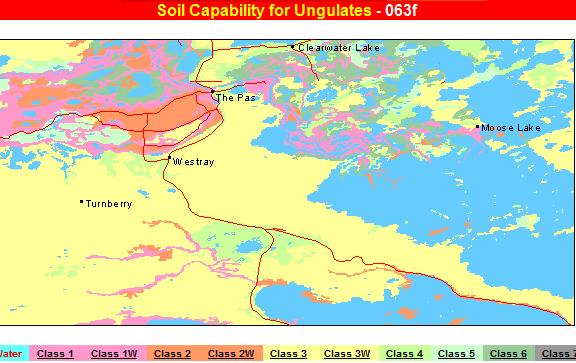
LAND CAPABILITY FOR UNGULATES
Twelve percent of the lands in the area have been rated Class 1, 7 percent
rated Class 2, and 60 percent rated Class 3. The rest of the land area has
moderate to low capability and has been rated Class 4, 5, or 6. Water bodies
occupy 1783 square miles or 31 percent of the area.
Caribou is the indicator species for 53 percent of the land in the area. This includes a large part of the forested plains south of the Saskatchewan River delta and some smaller units north of the delta. Forbs, sedges, grasses, and shrubs in the bogs and fens are important components of the caribou's summer and early winter ~ diet. Ground lichens, more abundant on the drier upland sites, constitute the staple winter food for caribou·
Moose, the most common wild ungulate in the area, is the indicator species for 47 percent of the classified land. The best moose habitat is found mainly in the lush riparian woods and on the rich deltaic plains. White-tailed deer and elk are secondary species in the area and capability ratings for both species are less than Class 4.
Poor interspersion of landforms necessary for optimum wild ungulate habitat (Subclass G) is the main limitation on 65 percent of the land classified. Excessive or deficient soil moisture (Subclass M), which is detrimental to the wild ungulates or their food plants, is the chief limitation for 19 percent of the land classified. This limitation is indicative of the high water table found throughout much of the area. Three and one-half percent of the land classified is limited mainly by low fertility (Subclass Fl, and one-half of one percent is limited mainly by a restricted rootingzone caused by bedrock (Subclass R).
Farming on the Saskatchewan river delta east and southwest of The Pas has reduced available moose habitat. However, a greater loss of high-quality habitat occurred when the Grand Rapids hydroelectric dam on Cedar Lake caused permanent inundation of about one third of the lower delta. If the Saskatchewan River delta is not disturbed further, moose will probably continue to flourish there. The forested plains south of the delta produce little merchantable timber and most of the soils are unsuitable for agriculture. Therefore extensive human disturbance of the habitat is not likely and its utilization by caribou will probably continue.
[Table of Contents]
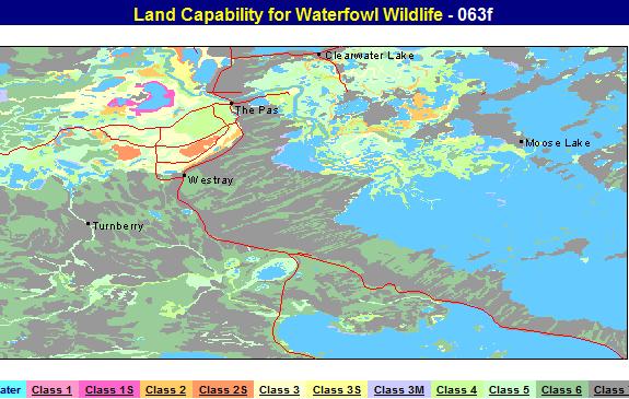
WATERFOWL ECOLOGY
The area lies in the Manitoba Lowland Section of the Boreal Forest Region.
The prevailing vegetation on the well-drained sites is chiefly white spruce
(Picea glauca), white birch (Betula papyrifera), trembling aspen (Populus tremuloides),
jack pine (Pinus banksiana), and balsam poplar (Populus balsamifera). Forest
vegetation on the poorly drained sites is black spruce (Picea mariana), tamarack
(Larix laricina), and small isolated stands of eastern white cedar (Thuja occidentalis).
However, the vegetative cover is greatly influenced by local soil and moisture conditions and deviations from the typical Boreal forest components occur in the Saskatchewan Delta. The flats support meadow grasses and marsh vegetation, whereas the peatlands are vegetated by sedges, grasses, willows (Salix spp.), and dwarf birch (Betula glandulosa). Mixed woods composed of balsam poplar, trembling aspen, white spruce white elm (Ulmus americana), green ash (Fraxinus pensylvanica), box-elder (Acer negundo), and speckled alder (Alnus rugosa) grow on the higher levees.
Wetlands in the area may be roughly divided into those sites that are usually permanently flooded and hold surface waters throughout the year, and those sites that are subject to seasonal flooding or are characterized by saturated organic soils.
The area includes five types of open water bodies: deep lakes shallow eutrophic lakes shallow drawdown lakes bog lakes, and open water marshes. Deep, fresh, or slightly brackish water lakes include lakes with mean depths exceeding 5 feet, and with a mineral soil or rocky shoreline. Examples are lakes Winnipegosis Red Deer, Cedar, and Atikameg. Aquatic vegetation, which is usually confined to shoals or offshore zones, consists of flat-stemmed pondweed (Potemogeton zosteriformis), big sheath pondweed (P. vaginatus), and claspingleaf pondweed (P. Richarsonii).
Shallow (less than 5 feet deep), eutrophic lakes are characterized by shorelines of mineral soil or pest, an emergent hinge of cattail (Typha latifolia) or hardstem bulrush (Scirpus acutus) and a silt or muck bottom vegetated by dense rooted aquatic plants such as big sheath pondweed, claspingleaf pondweed, spatterdock (Nuphar variegatum), northem water-milfoil (Myriophyllum erelbescens), common cottontail ( Cerstophyllum demersum), and musk grass (Chara spp.). Examples are Elm, Murphy, and Mawdesley lakes. Shallow drawdown lakes are usually less than 5 feet deep, and are characterized by sparsely vegetated and recessional shorelines, and a sandy or silty bottom. Their waters are often turbid and may undergo considerable fluctuations in levels such as Kelsey Lake.
Bog lakes are usually characterized by restricted drainage, stained water, a conspicuous floating mat shoreline, and a bottom layer of deep organic sediment; these include Watkins, Cul de Sec, and a bog lake located in the Lacustrine Plain north of Overflow Bay The common aquatic plants in these lakes are floating-leaf pondweed (Potemogeton natans), spatterdock, common bladderwort (Utricularie vulgeris), and aquatic moss (Drepenocladus sp.).
Open water marshes are vary shallow, semi-permanent areas of open water which usually have mineral soil shorelines an interspersion of offshore emergents such as hardstem bulrush and cattail, and abundant growths of submergent plants. The open water marshes support most of the aquatic plant species characteristic of other open water types but also sustain heavy growths of Canada waterweed (Anecharis canadensis), star duckweed (Lemna trisulca), variable-leaf pondweed (Potamogeton gramineus), sage pondweed (P. pectinafus), and Fries pondweed (P. freesb. This type includes Saskeram, Watseskwatapi, Pasquia and Shirley lakes.
Much of the area is covered by other wetland types that are characterized by consolidated organic soils 8nd a lack of large areas of open water. Wet meadows have a shallow organic surface layer underlain by mineral soils. The dominant plant species are blue joint grass (Calamagrostis canadensis), northem reed grass (C. inerpansa), beaked sedge (Carerx rostrata), awned sedge (C. atherodes), and willows such as Salix discolor and S. bebbisna. Wet meadows are extensive in the Saskeram, Reader, and Pasquia districts.
Sedge fans are peatlands that are saturated with alkaline waters and are blanketed by layers of moderately to poorly decomposed peat from 1 foot to more than 8 feet in depth. The surface vegetation consists of sedges such as beaked sedge and water sedge (Carex aquatilis), northem reed grass, horsetail (Equiseftm sp.), hoary willow (Salix candide), and dwarf birch. Patterned fans with low ridge and swale microrelief are more common on the Till and Lacustrine plains, where the hummocks and low ridges support stunted tamarack. Floating fans which are common around the periphery of bog lakes and sluggish streams, are floating mats consisting of decomposed sedges and aquatic mosses. The characteristic vegetation includes water sedge, wooly sedge (Carex lanuginosa), horsetail, sweet gale (Myrica gale), bog bean (Menyanthes trifoliata), hoary willow, marsh cinquefoil (Potentilla palustris), cattail, and often an outer fringe of common reed (Phragmites communis).
Marshes which usually occupy seasonally flooded, non-peaty areas or shallow basins of lakes are recognized by solid or interspersed stands of emergents such as hardstem bulrush, softstem bulrush (Sclrpus valldus), common reed, spangrerop (Scolochloa festucacea), awned sedge, and cattail. Other less common emergents include smartweed (Polygonum amphibium), horsetail, giant bur-reed (Sparganium eurycarpum), and sweet flag (Acorus calamus). Pools support growths of submerged and floating plants. Swamps are forested wetlands dominated by alder, willows, balsam poplar, tamarack, and black spruce. They are most common on levees, margins of peatlands and on alluvium.
Bogs or acidic peatlands have a moss substrate overlying fibric peat. The vegetation cover consists of forests of black spruce and tamarack with a shrub layer of leather leaf (Chamaedaphne calyculata), and Labrador tea (Ledum groenlandicum). Examples of true bogs occur throughout the Lacustrine Plain, The Pas Moraine, and at a few isolated sites in the deltas.
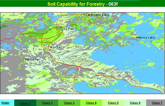
LAND CLASSIFICATION FOR FORESTRY
The entire area is in the Manitoba Lowlands Section of the Boreal Forest Region.
The forests are mainly composed of coniferous trees, such as white spruce,
black spruce, jack pine, tamarack, balsam-fir, and white cedar, along with
an admixture of deciduous trees, such as aspen, poplar, white birch, white
elm, green ash, and Manitoba maple.
The distribution of forest stands and their species composition is closely related to physiographic features and surface deposits. White spruce occurs on normally drained alluvial and lacustrine deposits and on deep till deposits with adequate moisture conditions and grows in pure stands or mixed with black poplar, balsam fir, black spruce, or jack pine. Black spruce stands are found on a variety of landforms, ,but they prevail on poorly drained depressional, flat sites and on shallow organic deposits, they generally have an admixture of tamarack and in some places, of eastern white cedar. Jack pine grows in pure stands on shallow till plains, till ridges, and gravelly beaches. As a result of repeated fires, it may occur mixed with aspen and black spruce. Because of climatic conditions, the highest capability in the area is Class 2, which occurs locally only as a part of the complex in the delta part of the area. Most of the land area has low capability and is rated as Class 6 and 7, followed by Class 5 and some Class 4.
The main parent materials in the area are glacial deposits in the form of ground moralnes, drumlinized till plains, or as thin till veneer over limestone bedrock. Because of a complex glacial history the till deposits are frequently modified or reworked by water and resemble lacustrine clays. The present soils developed on till deposits generally have a sandy loam or silty loam texture and a high calcium carbonate content. The fairly high productive capacity of till deposits for this climatic region is limited by adverse drainage conditions, petrographic composition, and depth to underlying bedrock. Class 4 capability for forestry is common on normally drained till deposits. The most frequent limiting factors are soil moisture deficiency (M) or surplus (W), excessive level of calcium (L), and restriction of the rooting zone by bedrock (R).
The glacial lake deposits are closely associated with depressional, flat topography, poor drainage, and the presence of organic accumulation. As a result of glacial and post glacial processes, the silty lake sediments also overlie some till deposits. On the fine-textured lacustrine plain, numerous gravelly beaches and strandlines indicate the shorelines of former glacial lakes. Prominent beaches along the western edge of The Pas moraine show a sharp contrast to the monotonous lacustrine plain surroundings. The productive capacity of these lacustrine soils in the area is controlled mainly by drainage conditions. Because of the flat, depressional surface topography, the water table is frequently near the surface and excess soil moisture is the most common limiting factor. The capability of these lacustrine soils is generally very low, Class Gand 7, some class 4 and 5 land occurs on slightly better drained sites.
Silty clay alluvial deposits occupy about 25 percent of the area and occur mixed with organic accumulations on the deltaic plain and on the flood plains of small rivers and streams. The natural high productive capacity of alluvial soils is limited by periodic inundations and very poor drainage. Narrow, natural levees and artificial drained parts of the delta are rated as Class 2 or 3, whereas depressional flats behind the levees, which are composed of similar soils, are in most cases saturated, wet sites that are not suitable for the growth of commercial forests and are rated as Class 7.
Organic accumulations of decomposing veg!ation are very common and occupy about 20 percent of the land area in association with till, lacustrine, and alluvial landforms. Their productive capacity is generally low; they are rated Class 6 and 7, depending on the depth to mineral soil and on the degree of saturation. Slightly better drained, shallow organic deposits may support black spruce and tamarack stands and may be rated as Class 6, whereas extremely wet soils and deep peat deposits and rated as Class 7.
Capability classification by P. Gimbarzevsky in cooperation with S. C. Zoltai, Canadian Forestry Service and Jean Thie, the Forestry Sector, Canada Land Inventory Project, Manitoba, Department of Mines, Resources and Environmental Management. General description by P. Gimbarzevsky.