

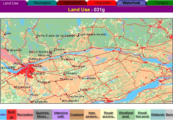
The Canada Land Inventory provides one of the most comperhensive digital map sources for resource planning ad management in Canada. The area covered by the CLI is indicated in the index map.For each of the map sheets areas land capability is mapped at 1:250'000 scale and usually at a 1:50'000 scale. This is an example for Mapsheet 31G, Ottawa and Gatineau covering part of Ontario and Québec. The index map on the right shows the areas mapped for Ungulates capability under the CLI. The left image shows an example of a number of overlays displayed on Google Earth
Each of the 1.250'000 scale maps has an extensive description of the lanscape ecosystem and capability perspectives. Below is an example for Ottawa-Gatineau map area.
GENERAL DESCRIPTION OF THE OTTAWA- GATINEAU AREA, 31G
1. INTRODUCTION
2. CLIMATE
3. MAIN SOIL CHARACTERISTICS
4. AGRICULTURE
5. ECOLOGY
6. WATERFOWL CLASSIFICATION
7. FOREST ECOLOGY
ONTARIO
9. LOCATION AND DEVELOPMENT
10. GEOLOGY AND GEOMORPHOLOGY
11. CLIMATE
12. FOREST ECOLOGY
13. RECREATIONAL CAPABILITY
QUEBEC
15. LOCATION AND DEVELOPMENT
16. GEOLOGY AND GEOMORPHOLOGY
17. CLIMATE
18. FISH AND WILDLIFE
19. SETTLEMENT AND LAND USE
20. RECREATIONAL CAPABILITY
1. INTRODUCTION
The Ottawa map sheet includes part of south-western Quebec and part of what
is referred to as Eastern Ontario. In Quebec, it covers a large part or all
of the following counties: Gatineau, Hull, Papineau, Argenteuil, Two-Mountains.
Vaudreuil, Soulanges, Beavharnois and Huntingdon. In Ontario, it covers parts
of the counties of Carleton, Lanark, Grenville, Dundas and Stormont and all
of the counties of Glengarry, Prescott and Russell.
Roads in the region are good to excellent and sufficient in number to provide
easy access to both local and distant markets. Highways Nos. 2, 401, and 17
are common to both provinces and provide links between the two largest urban
centres of the map area: Ottawa-Huh and Cornwall with Montreal and with Toronto.
Other important high• ways of the map area are, in Quebec: Nos. 8, 11, and
the Laurentian Autoroute, and in Ontario: Nos. 16, 31 and 43. The area is well
served by rail and is crossed by the Transcanadian lines of the Canadian National
and of the Canadian Pacific Railways. The St. Lawrence Seaway goes through
the southeastern corner of the mop area.
The central part of the area is traversed from west to east by the Ottawa River,
which separates the two provinces, and partly delineates the hills of the Precambrian
Shield, called the Laurentians, from the level to undulating area of the St.
Lawrence-Ottawa lowlands. The hills occur exclusively in Quebec on the north
side of the river. The lowlands occupy the whole map area in Ontario and extend
in Quebec along the eastern edge of the map.
The hilly area is covered by sugar maple as the dominant tree, with a variable
proportion of beach, birch, basswood, balsam, fir, spruce and white pine, according
to exposure and moisture conditions. Red oak is often dominant on the warmest,
driest hilly sites. In the lowlands, the tree cover varies considerably and
consists mainly of sugar maple on the well drained soils of medium texture,
of red maple, elm and block ash on the moist fine texture soils and of white
pine on the dry sandy locations. Red cedar (i. virg.) is often found on the
shallow soils over limestone.
[Table of Contents]
2. CLIMATE
The climate is of the cool continental type, with usually adequate average
precipitation during the growing season. Snow is abundant in the winter. The
best climate is found in the south east portion of the map area, where it is
a few degrees warmer than the north western portion. Over the entire area,
the mean annual temperatures ranges from 390F. to 430 F., the average frost-free
period from 120 to 145 days and the growing season, from 185 to 197 days. The
average annual precipitation ranges from 30 inches to 40 inches, in the various
sectors of the map, except in the north-east sector where it exceeds 43 inches
[Table of Contents]
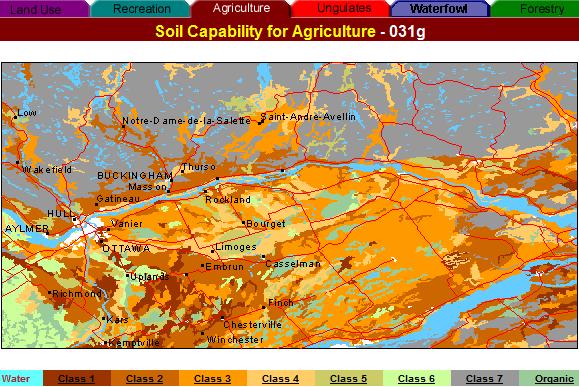
3. MAIN SOIL CHARACTERISTICS
The hilly area varies in elevation from 500 to 1500 feet and is dissected by
narrow valleys situated between 400 and 800 feet of elevation and orientated
from south to north. The hills are made up mainly of stony soils of the Acid
Brown Wooded group. The northern parts of the narrow volleys consist of Podzols
formed on sandy and gravelly outwashes. The southern ports of these some valleys
often consist of Humic Gleysols formed on fine texture deposits.
The lowland area lies between 100 and 400 feet of elevation and consists mainly
of calcareous tills, marine clays, and alluvia sands generally over-lying the
clays. Organic deposits are also found in the low-lying areas. The till soils
are generally of loam to sandy loam texture, moderately to imperfectly drained
and belong to the Brown Forest group. The clay soils are imperfectly to poorly
drained and belong to the Humic Gleysols. The soils bordering the Ottawa River
soils have a higher clay content and somewhat poorer structure than those around
North Cower and Inkerman. The sandy soils of the lowlands belong mainly to
the Podzol group and vary from excessively to imperfectly drained.
[Table of Contents]
5. ECOLOGY
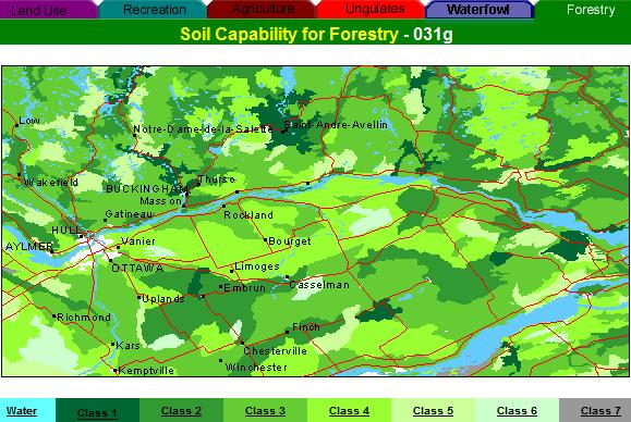
The predominant forest cover of the area of conifers in the northern stet.
The dominant deciduous species are sugar maple (Acer saccharum) and beach
(Fagus grandifolis) with red maple (Acer rubrum), yellow birch (Betula lures),
and white elm (Ulmus americana). Among the conifers, hemlock (Tsuga canadensis),
white pine (Pinus strobus), white spruce (Picea glsuca), and balsam fir (Abies
balsamea) are common.
The remaining forest cover of the intensively farmed lowlands is varied and
consists primarily of sugar maple on the medium-textured, well-drained soils,
red maple. elm, and black ash (Fraxinus nigra) on the moist, fine-textured
soils, and white pine on the dry, sandy soils. Red cedar (Juniperus virginiana)
is common on the shallow soils over limestone.
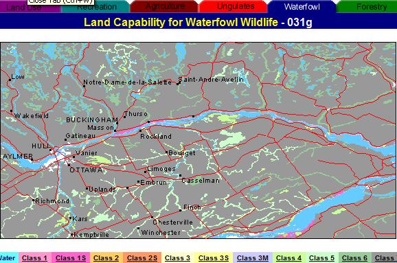
Most of the high quality wetlands in the map area are located along the Ottawa,
St. Lawrence, and Rideau rivers. Emergent vegetation in these marshes includes
sedges (Carer spp.), pickerelweed (Pontederia cordata), arrowheads (Sagittaria
spp.), wildrice (Zizania aquatical, river bulrush (Scir pus fluviatilis), burreed
(Sparganium sp.), and cattail (Typha latifolia). Submergents include white
and yellow waterlilies (Nymphaea spp. and Nuphar spp.), watershield (Brasenia
schreberi), pondweeds (Potamogeton spp.), eelgrass (Vallisneria americana),
watermilfoils (Myriophyllum spp.), and smartweeds (Polygonum spp.).
Waterfowl habitat in the interior of the lowland region is generally poor.
Most of the dabbling duck nesting places are situated near the tributaries
of the Nation and Raisin rivers. Some sections of these tributaries are good
for the production of waterfowl. Lakes and shallow ponds are rare in the lowlands,
although several organic depressions are present; waterfowl utilize such sites
to a limited degree. The largest of the organic sites are the Mer Bleue and
Alfred Bog, both of which are raised sphagnum bogs.
Marshes in the Gatineau uplands are of poor quality except for the scattered
beaver ponds and small shallow lakes. The dominant emergent vegetation in these
upland marshes is cattail, bulrush, and sedge. Submergent vegetation consists
mainly of white and yellow waterlilies, pondweeds, and watershield. Many lakes
also have borders of sweet gale (Myrica gale).
[Table of Contents]
ONTARIO
9. LOCATION AND DEVELOPMENT
The area covered bythe Ottawa map sheet comprises parts of southeastern Ontario
and southwestern Quebec. The Ontario Dart of the area includes much of the
lowland between the Ottawa River and St. Lawrence River and Seaway. It is within
the eastern Ontario development region, and includes many agricunural towns
as well as larger centers such as Ottawa and Cornwall. These larger centers
are mainly along the Ottawa end St. Lawrence rivers. A number of smaller centers
are found inland.
The Ontario part of the area is served by an extensive transportation system,
including main highways and railways, which join Montreal and the east with
both northern and southern Ontario. Much of the area has a system of rural
roads from 1 to 4 miles apart. The area is served by the St. Lawrence Seaway,
and by international airports at Ottawa and Montreal.
The Ontario part of the area is a lowland with flat to gently rolling relief
and practically no strongly broken relief. Elevations range from 150 feet to
400 feet and generally increase from east to west.
The soil materials tend to be shallow to the west where there are extensive
tacts of exposed sedimentary rock, and somewhat deeper to the east. The soil
materials include clays and other fine materials of lacustrine or marine origin,
fine sands of deltaic origin, and loams of drumlin or morainic origin.
[Table of Contents]
10. GEOLOGY AND GEOMORPHOLOGY
The broad belt south of the Ottawa River tends to be flat to very gently undulating
or rolling. It contains extensive clay flats at 150 to 200 feet above sea
level; these are generally low in lime and develop moist soils. Several plateaus
of fine deltaic sand occur at 200 to 250 feet above sea level. These have
a water table, and they vary in relief from smooth to hummocky. The soils
are sometimes fresh, and may vary from fresh to wet within very short distances.
There are also extensive swamps and bogs in this region. The lower St. Lawrence
River region is gently rolling and the surface varies from smooth to hummocky.
The soil material is largely of till origin, is generally high in lime, and
is loamy textured. The soils are generally fresh, but there are many pockets
of moist to wet soils. Pockets of moist clay, moist deltaic loams, and extensive
swamps also occur. The southern part of the area, in the Winchester vicinity,
contains extensive tracts of clay. These generally have very fresh to moist
soils and very
gentle topography. They are frequently interspersed with small- to medium-sized
drumlins of fresh loam till. This region has some excellent farmland.
Immediately south of Ottawa there is an extensive region of fine sand along
the Rideau River. This region has gently undulating relief and is somewhat
hummocky, so that the water table and soil moisture content vary widely within
short distances. West of Ottawa there are extensive regions of Paleozoic sedimentary
rocks, largely ddomite, limestone, and sandstone. These regions havegently
rolling or undulating relief that is broken to some extent by small scarp mere
are many shallow broad basins in the rock, which are frequently occupied by
very wet organic soils. Elsewhere, the soil material generally ranges in depth
from exposed bedrock to shallow, and there are a few tracts of deep soils.
The materials are of variable texture.
[Table of Contents]
11. CLIMATE
The climate of this region, and the response of vegetation to combinations
of climate and landform, place it in Site Region 6E for Ontario, which is
one of the more favorable climatic regions of Ontario. The growing season
is 189 to 198 days, end the frost-free period is 130 to 150 days. fne annual
precipitation of 34 to 38 inches is among the highest in Ontario; it appears
to be distributed fairly evenly during an average year. The July mean temperature
is 880F to 69'F, the January mean is 120F to 150F, and the annual mean 420F
to 440F. There are 3250 to 3400 growing degree-days above 420F. Because of
the gentle relief, the local climate tends to be uniform, though there is
some variation in precipitation within the area. Also, the settling of cord
air may cause frost pockets.
[Table of Contents]
12. FOREST ECOLOGY
At present, forests are largely restricted to wet regions and other regions
of limited capability for agriculture, and to farm woodlots, some of which
are on very good soils. Theforests mainly consist of tamarack and black spruce
on very swamp sites, and sugar maple on deep organic materials and moist
mineral matenals. The forest on fresh soils consists largely of sugar maple,
with lesser amounts of basswood, white ash, and white pine. Stands of similar
composition, but of much lower quality, occur on very shallow and shalloYroaieouer
bedrock. On dry and fresh sand, the forest cover may include sugar maple
and pioneer species, such as poplar. These sites have a high capability for
growing good stands of red and white pine.
Mapping units and capability classes byJ. R. M. Williams and G. A. Hills, based
on field work, Ontario soil survey reports, and other sources.
[Table of Contents]
13. SITE REGIONS
For a descri ption of Site Regions refer to the Ontario Regional Class Description
in Land Capability Classification for Forestry, prepared for the Canada Land
Inventory by R. J. McCormack, Department of Regional Economic Expansion.
Report No. 4, 2nd Edition, 1970.
[Table of Contents]
14. RECREATION CAPABILITY (ONTARIO)
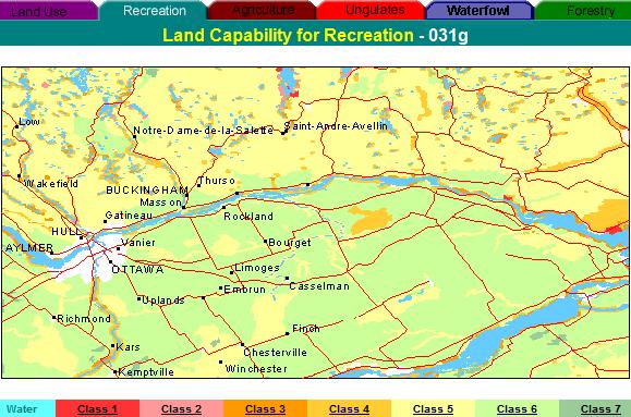
In the Ontario part of the area, the scenic Ottawa, St. Lawrence, and Rideau
waterways and the many historic features found throughout the area are main
tourist attractions. These water systems are the most intensively used recreation
features; however, the lack of good bathing beaches limits their capability
for recreation. The highest rating for bathing, Class 3, occurs just east
of Lancaster, on the St. Lawrence River. A Class 2 lodging site, located
on the Ottawa River west of Shirley's Bay, is the best for the entire area.
There are extensive possibilities for viewing and hunting upland game such
as white-tailed deer md Hungarian partridges. The potential is less extensive
for wetland wildlife, which tends to be more concentrated along the shorelines.
The Mer Bleue and the Alfred Bog are atypical ecosystems in this part of
the province. Alfred Bog supports one of the few moose herds in Southern
Ontario. The chief tourist attraction in the area is the city of Ottawa,
the capital of Canada. This city of about
300,000 people contains many features of interest to the visitor, including
the Public Archives several national museums, the Parliament Hill. The range
of recreational activities in the Ontario part of the area is somewhat limited;
however, the city of Ottawa and the Rideau Waterway provide high-quality
recreation and tourist potential.
[Table of Contents]

19. FISH AND WILDLIFE
The Ottawa River, from Ottawa to Papineauville, and the St. Lawrence River
are marshy in many places providing excellent habitat for fish and waterfowl.
The waters of the area are well-stocked with pike, bass trout, maskinonge,
walleye, and many varieties of panfish. Ducks are found mainly along the Ottawa
and St. Lawrence rivers, and geese are also found along the Saint Lawrence.
Upland game consists mainly of white-tailed deer, grouse, Hungarian partridges
rabbits, and squirrels.
[Table of Contents]