The policy domain is one of the most interesting and challenging parts of organizational and societal management. It is always there, in a written or unwritten form, but it is very seldom very effective in using the best science or knowledge, in responding to issues or reflecting the long term future dimensions.
We provide a number of special services which target the science-technology-policy-practice links and reduce barriers between these areas.
The Policy Cycle provides a simplified way of visualizing the policy management process, and assist in targeting the most effective way of influencing this process in your organization or sector. While the policy cycle is far from a linear and circular, it is important to understand the links between the various phases to improve the process.
The Global Sustainable Development Policy Framework helps to visualize the complex interactions between the economic, social and environmental pillars and scalability from global to local. It can assist in positioning an organizations policy history and policy strategic intent. We developed such an approach for the IUCN- The World Conservation Union.
Science-Policy-Issue-Cartography is one of the areas of special interest to us. This approach was developed for a series of high profile National Atlas of Canada Poster Maps, which were distributed in cooperation with Canadian Geographic. Titles include: Wetlands of Canada, Canada's Boreal Forests, Natural Hazards. They all were based on a "facilitation approach" of a multi-stakeholder group of experts and a wall size version of the framework to prioritize issues, describe historic dimensions, assess economic, social and environmental benefits and stresses, and explored future scenarios for policy alternatives.
Policy and Knowledge Infrastructure is of special importance for organizations which have a strong science and technology base. This concept and strategy evolved from a project with the Canadian Forestry Service to assess the importance of Spatial Data Infrastructure. With senior scientist and managers we developed an "infrastructure blueprint" and targeted strategies mapped in this blueprint to reduce barriers between science, policy and action.
Policy Impact Mapping. In a project for the IUCN-The World Conservation Union we mapped the influence of a series of knowledge products and policy as part of a larger study carried out by Dr.Zenda Ofir.The thumbnail map shows the influence of the Global Red List of Threatened Species related to knowledge development, empowerment of organizations and impact on policy development and governance. The Red List is major research and monitoring project of the Species Survival Commission of the IUCN. It is developed with the assistance of thousands of volunteer experts around the world, and has achieved a unique level of scientific and policy credibility."Red listing" is directly linked to species protection policies, regulation and legislation in many countries around the world.
Policy Cycle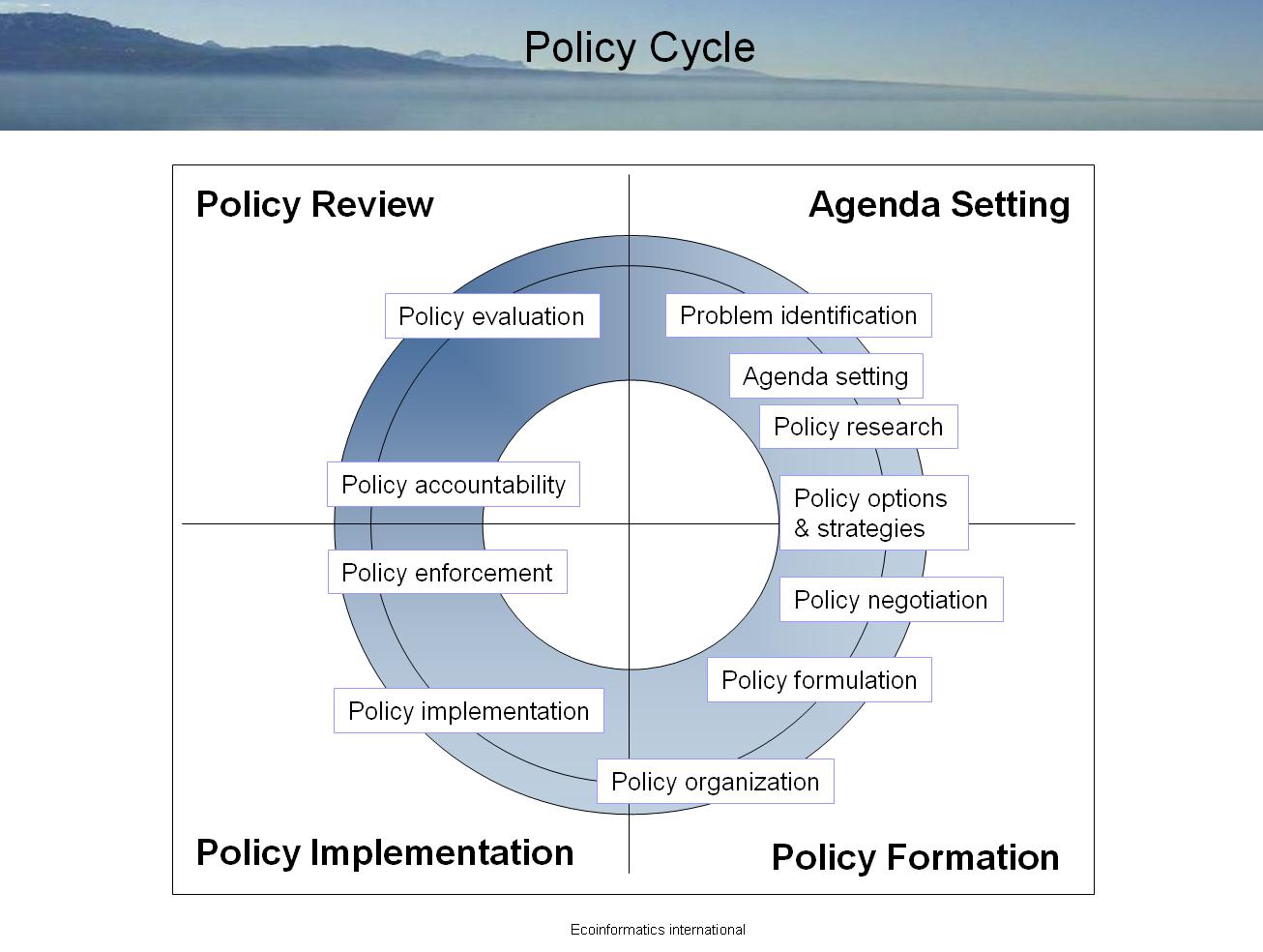
Global Policy Framework
IUCN Policy History Mapped In Global Policy Framework
Science -Policy Cartography
Policy and Knowledge Infrastructure
Policy Impact Mapping
Mult-stakeholder models for policy
