An excellent selection of sites in the Yukon showing significant slides and regression of permafrost in mineral soils was made available on Google Earth by "kingpointnorth" (Google Earth BBS link no longer available, but this link is to my record of his locations) in 2005. Some of the sites he found have a high resolution satellite image coverage. An example is the Caribou River Thaw SlideRiver which I describe below in more detail.
In the context of climate warming, it is interesting to look at some of these sites over a period of 50 years or more. Aerial photography has been taken in the North since the mid 1920's. From the 1950's on aerial photography becomes a more dependable source of information for comparison. (See the National Air Photo Library on-line site).
I have taken a few if the sites and analyzed the information below from a time series perspective.
This site is within the Peel River Plateau Ecoregion and the Taiga Plain Ecozone. The landscape is almost entirely shaped as result of the Laurentide glaciation, and post glacial fluvial and other geomorphological processes. Continuous permafrost is present with depth to base of ice-bearing permafrost close to 300m (Geological Survey of Canada, unpublished data). Retrogressive thaw flow slides are common where ground ice has been exposed in glaciolacustrine deposits by forest fires, debris flows and regressive erosion. (Ecoregions of the Yukon: Peel River Plateau).
Figure 1 The Permafrost slide area as seen on Apple Maps -Most recent and high resolution image.
This slide is certainly a very spectacular feature. Its width is about 850 meters and it has an interesting history starting just before 1950.
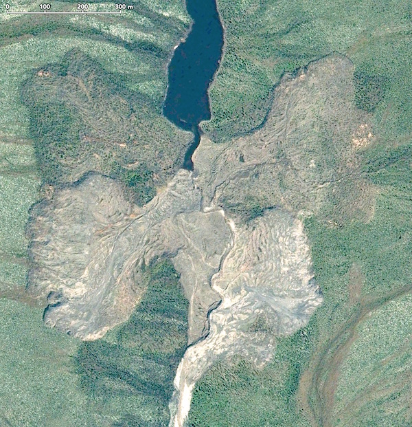
Figure 2 The Permafrost slide area as seen on Google Earth 2007 :
(GOOGLE EARTH KML link for this site)
Original source 2007 Digital Globe high resolution image. The red marker is from the selection of regressive permafrost slides marker selection provided by Kingpointnorth. The relative recent disturbed bare soil is clearly visible on both sides of the creek. Also the adjacent areas on both sides show significant sliding area which appear to have been stabilized and are recovered with vegetation.

The complexity of the slide area and the apparent long history should make it an interesting object for further study. The images and discussion below give a simplified historic perspective based on the interpretation of satellite and airborne images taken since 1950.
Figure 3 Interpretation of the History of the Permafrost Slide Area.
This figure represents the air photo and satellite image interpretation since 1950. The earliest available air photos taken in 1950 showed that the first slide started on the right side of the creek, in effect the south facing slope. It appears to have been a sudden event. The pink arrow shows the slide path, which also blocked the creek flow, and created a small lake upstream. The the water erosion from the displaced creek started to undermine the north facing slope which showed a steady regression for the next 27 years before stabilizing. Just before the 1990's additional regression occurred on the south facing slope (thin orange line) also occurring as a sudden failure. The new slide areas (yellow dotted line) developed between 1990 and 2000.

Wildland fires are not the cause of the melting in this case. During the period 1950-2007 no wildland fires were recorded (see below) nor any signs of fire marks were visible on any images since 1950. The closest fire was about 5 km distance from this location
Figure 4. Retrogressive Slide on 1950 and 1953 Aerial Photos
Canada's National and Provincial Air Photo Libraries provide an important environmantal baseline to measure and visualize change. The 1950 National Airphoto Library photo (A12847-144) was taken on August 2nd, 1950 at a height of 20'000 ft. Original scale 1:40'000. The pink arrow shows the flow direction of . The slide, on the south facing slope occurred as a sudden event blocking the flow of the creek and creating a small lake upstream. The drainage channel was pushed into the opposite slope which started to collapse. Both sides continued to melt, but most of the regression in the following decade is in the north facing slope. The 1953 airphoto (A13753-22) was taken on 27 July from 35'000 ft.

Figure 4. The Next 20 Years
During the next 20 years the North facing slide is regressing. The 1972 and 1977 air photos show that the creek is pushed back again (yellow marker). In this 5 year period the North slide appears stable, and some further sliding occurred on the south facing slide (from blue dotted line to the light blue-grey dotted line). There are no signs of fire scars in the vegetation on these photos, but a fire scars ( (dated between 1958-1978) were identified in close to the Salter Hill area, about 5 km distance from this slide area. 1972 Airphoto (A22972-119) taken on 11 July, from 35'000 ft; 1977 air photo (A24761-133) taken on August 1, from 35'000 ft.

Figure 5: NASA Landsat Pseudo Colour 1990 (left) and 2000 (right). The pink arrow on the 1990 satellite image shows that the south facing slope has become active again. Also the light blue arrow shows the start of the next phase on the north slope. The 1950 and 1970 slide areas still look reasonably stable and are covered with vegetation again. The red arrow on the 2000 image shows a part of the 1950 slide which has become active again: the small dark black area- a mudflow The yellow arrow on the 2000 image points to the dark purple active slide area essentially very similar to the Google Earth image (2007). No fire scars are visible on each of the images.

Figure 6: Fire History for the Yukon 1946-2004. The map below depicts the wildland fires since 1946. Source: Yukon Energy, Mines and Resources. The Caribou River area described here is marked with the red marker near (1). The closest fires on this map was (3) which occurred between 1990 and 1999. The Trevor Range Site (green marker) is identified with a (2). It will be interesting to study the blue markers provided by kningpointnorth in relation to fire history. A cursory review of some of the sites in recent and older burn areas seems to imply a link with the fires. Legend: Grey= 2000-2004; Red=1990-1999: Pink=1980-1989; Green= 1970-1979; Orange= 1960-1969; Yellow=1950-1959; Light Green= 1946-1949 (not on this part of the map)

Figure 7: Topographic Map of Study Site (red circle)
