Wildland fires are an important and integral part of Boreal Ecosystems around the world. Satellite images from ERTS (in the early days of remote sensing) Landsat and SPOT, have made this clearly visible. This image below was taken by the ERTS Satellite on March 7, 1974. It is the one of best example of the role of forest fires as an integral part of the ecosystem . I selected this image when I was Head of Applications Development at the Canada Centre for Remote Sensing, in Ottawa.
Because this is a winter image and all areas are covered by snow, the reddish brown tones reflect the density of the vegetation, forest stands. All vegetation cover in this area is of fire origin and has been burned at least once in the last one hundred years and many areas 2,3 or 4 times. Some of the dark areas in the top of the image ( the oldest stands, have not been burned in the last 100+ years).
Climate has always had a significant role in wildland fires. Lightning is probably the largest cause of fires in this part of Canada. A warming climate is expected to increase fire activity and severity. The area burned may double over the next century.
1974 ERTS Satellite Image. taken on March 7, still winter in this part of Canada.

Below: Google Earth Image showing part of the 1974 Landsat Image area 30 years later.

When you fly with Google over Canada's Boreal Ecoregion (above), you will see the intricate and beautiful patchwork of forest stands created by its fire history. GE provides an opportunity to look closer at the effects of wild land fires and recovery of vegetation. Zooming in to see more detail GE shows the recovery rate of vegetation and gives an indication of the fire history. This image below shows a typical example of fire history.
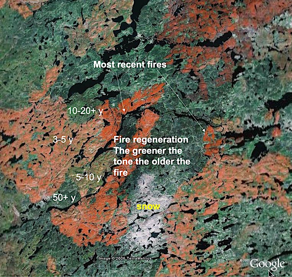
Forest Fire History Interpretation
The recent burns (last 1- 10 years) show up from light to deeper orange. The deep orange are the most recent fires. But also the green areas have been burned one or more times in the last 100 years.

Winter snow cover enhances the visibility of fire patterns. Recent burns (1a)lack vegetation and are completely snow covered, showing as almost pure white (1b). In Burn areas of 5-10 years old (2a)regeneration has established and young trees cover part of the snow and show up as grey areas(2b). The dark areas(3) are older forest stands, which are invariably of fire origin.

Canadian Wildland Fire Information System
Canada has a well coordinated approach to monitor forest fires. The Canadian Inter-agency Forest Fire Centre (CIFFC http://www.ciffc.ca/ ) provides operational fire-control services , management and information services and coordination with the United States and other countries. The Canadian Forest Service has a an exceptional informative web site. Also the National Forest Information System, provides under the umbrella of the Canada Council of Forest Ministers a very informative website and data base.

The image above shows large fires, greater than 200 Hectares in Canada and Alaska for the time period from 1950 to 1997. This image is taken from a publication by E. Heyer. It gives a good sense of the age of wildland fires in the various ecoregions of Canada.
Although the map is at a very small scale and gives approximate positions of the fires, it can be correlated with Google Earth imagery. Of course since 1997, the last year of fires on this map, significant areas were burned.


peatlands form one of the dominant features of Canada's Landscape: over 12% or 1.136 million km2 are peatlands in Canada. He estimates also that these peatlands contain about 56% of all the organic carbon stored in Canadian soils.
This peatland sensitivity map was produced by Kettles and Tarnocai in 1999 and appears in a recent article "The Effect of climate change on carbon in Canadian Soils. (Available on line through Elsevier's www.sciencedirect.com- global and planetary change 53 (2006) 222-232).
peatlands are expected to be severely effected by climate change and a large part of the carbon could be real eased into the atmosphere as carbon dioxide and methane.
Since both wildland fire frequency and peatlands permafrost melting are expected to be significantly affected by climate warming, it is interesting to look at the ecological links between the two. It is possible that the expected increase in wildland fires will accelerate permafrost melting and accelerate the release carbon form the significant peatland stores.
The two images below show the fire history since 1950 as well as the peatland sensitivity and permafrost situation. The distribution of fires (larger than 200 ha) seems to correlate with the most sensitive peatland areas (severe and extremely severe). The next decade will be critical to monitor whether permafrost melting in peatlands will accelerate and the role of fires in this process


Peatland sensitivity map as overlay in Google Earth in the "study" area
Google Earth Link to map overlay
Interesting National fire Information Links
The national fire perspective below is taken from the NFIS Satellite Forest Information System for the 1985-2015 time period:
