Jean Thie. Director EcoInformatics International
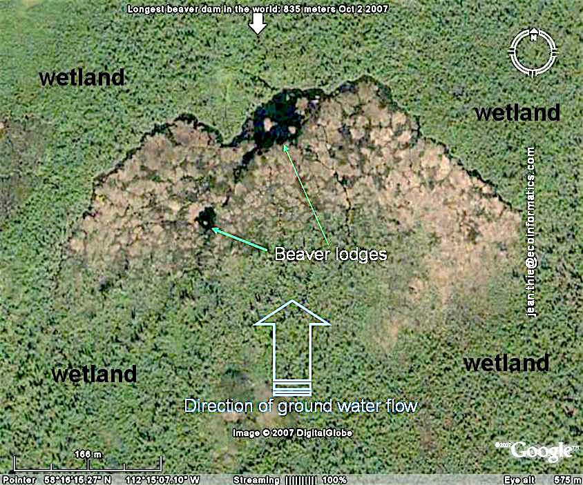
The longest beaver dam found with Google Earth to date (October 2, 2007) is located in Northern Alberta. The dam has a length of about 850 meters (2790 ft.). It has at least existed at this spot for over 25 years as it can be observed on the 1990 Landsat 7 Pseudo Color Imagery provided by NASA World Wind. However 1980 aerial photo's show that this dam did not exist yet in 1980..
The actual location of the world longest beaver dam (that is until someone finds a longer one) is just South of Lake Claire, and about 190 km to the NNE of Fort McMurray, just inside Wood Buffalo National Park.
Until 2008 Wikepedia listed as the largest dam, a dam near Three Forks, Montana, with 652 meters (2,140 feet) long, 4.3 meters (14 feet) high at the highest point, and seven meters (23 feet) thick at the base. We have not been able to find this dam on Google Earth.
Jean Thie of EcoInformatics found the beaver dam while using Google Earth to study environmental change in Canada's Boreal and Sub-Arctic Ecoregions. He was looking in particular for the rate of melting of permafrost in wetlands (typically occurring as palsas and peat plateaus in Canada's discontinuous permafrost zone). This type of permafrost occurs in a wetland 2 km to the east of the beaver dam.
The location of the 'longest' beaver dam was first posted on the Google Earth Community Forum on the 5th of October 2007. Since that time no larger dams appear to have been discovered anywhere else, underpinning the original 'tong in cheek claim' that it was (and still is) the longest beaver dam in the World!'
Longest beaver dam in the world found with Google Earth (Digital Globe): October 2, 2007
This dam was measured with the Google Earth Measuring tool to be about 850 meters in length. There is one major beaver lodge and possibly an older one. No surface water drainage can be seen. Water moves down the very slight sloping wetland. The (relative thin layer) of organic material of the wetland works as a sponge . The flow is slow and over a wide area of wetland which requires the building of very long dams. Many dams can be found in areas like this with lengths of 500 meters. Any dam over 600 meter remains exceptional.
The date the satellite image was taken is: 26 July, 2004. It is rather remarkable that this image is still used by Google and not replaced by a more recent photo. More recent images can be look at using Apple Maps or Bing Maps.
The aerial photos below were taken by Steve Anderson of Wood Buffalo National Park and appeared in a May 5 article of the Edmonton Journal by Karen Kleiss: Alberta beaver dam can be seen from space. (on line access to article no longer available). Of course the dam cannot only been seen from space, it was actually discovered by 'flying over the earth' with Google Earth. It is unlikely that this dam would have been discovered without Google Earth and its high resolution image data base. Google Earth uses in this case a Digital Globe satellite image.
The pictures also show near -A- new dams being build which could ultimately join the main dam and increase the overall length by another 50-100 meters in the future..


The actual search strategy was based on a preliminary observation hundreds of beaver dams across Canada. Based on these observations broad characteristics of landscape ecosystems were identified with the highest probability of high density and large beaver dams. These broad landscape characteristics were used to identify possible target "beaver landscapes". Each of these would initially be assessed using high resolution Google Earth images, and exceptional dams would be studied with aerial photographs available through Canada's National Air Photo Library in Ottawa.
The Wood Buffalo National Park Beaver Gallery provides a series of photos taken from helicopter and fixed wing aircraft for the dam. We have overlaid these pictures directly on ' Google Earth'. Below are the KMZ links to compare these images with Google Earth..


1975 Aerial photo of the dam area (left) : Some minor beaver activity can be observed (green arrows) but most of the area is covered by trees and shrubs. I expect this area was burned about 20-30 years before the date of the photos (1975). A even aged stand of stand of poplar (Po) is visible on the 1975 photo, has been replaced by a wetland in 2005. Of course poplar (Trembling Aspen) is a favorite food source for beaver and the stand did not survive very long. This image is part of flight line A24215 (photo number 253). Date: 9 August, 1975; original scale: 1:50'000. The dotted red line shows the present location of the beaver dam. As can be seen in this example, aerial photos from an important environmental baseline to assess environmental changes. Aerial photos of Canada can be obtained from the National Air Photo Library (NAPL). Also Provincial Air Photo Libraries are an important source. A 1980 Alberta Airphoto (2166-277-Alberta APL-1980-06-09-60k) shows that no construction had started. link

Comparison of the two images shows interesting elements. The dams 1 and 2 existed in 1970 but have changed very little. The beaver lodge near Dam 1, is still there. Dams 3 and 4 have been build since 1975. The beaver offspring of dam 4 are building two smaller dams just to the side (green arrow). Larger images [+]
Another satellite image source available in 2007 was the NASA World Wind System, which provided easy access to pseudo colour image coverage of Lansat 7 for 1990 and 2000. The resolution is much lower but the dam can be identified (red arrows). Clearly the dam existed already in 1990 and did not change much in size on the 2000 image. So most of the dambuilding must have happened between 1980 and 1990. Also it can be observed that the number of beaver dams increased visibly between 1990 and 2000. Of course the resolution of the 2000 Landsat imagery is superior to the 1990 Landsat.


This slight sloping area around the Birch Mountains was identified as a potential excellent habitat for beavers to buil long dams. after the study of a similar environment and beaver community near the Pasquia Hills in Saskatchewan. The NASA Landsat 7 Pseudo Color Image (2005) was taken from World Wind. Relief is exaggerated 5x to enhance the relief significance for beaver habitat and occurrence. The alluvial fans and associated drainage systems provide exceptional habitat. The alluvial fan system outlined in yellow dots shows a concentration of many large dams. The black arrow points to the 'longest dam', which is shown here by just a small 3-4 mm long thin line dark line.
Some of the high run off areas (purple) appear less suitable for or preferred by beavers.
This pseudo image with a near infra red band shows clearly the small open surface water areas representing (not always) beaver ponds. (Some of the black spots on the slopes are caused by cloud shadows).
The cross section in the figure below is along the white line on the satellite image. The red arrow is at the location of the longest dam. In the elevation profile this is at the line near the 235 m asl mark. The slope profile is typical for an alluvial fan developed and deposited in a receding glacial lake. Average slope of the wetland in which the beaver dams developed is 0.5%. 
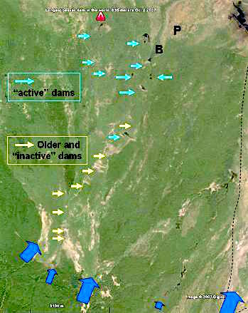
The Longest Beaver Dam as Part of a Beaver system. The alluvial fans are fed by a series of streams and creeks from the Birch Mountains (blue arrows). Because of the very low slope of the alluvial fans, drainage flows have shifted and no clear drainage channels have developed. Beaver dams and ponds identified with light yellow arrows seem to be inactive. The light blue arrows indicate active ponds and dams with lodges.
Wave modified strand lines can be seen near B. Just to the east peat plateaus (P) with collapse scars show the presence of permafrost in the wetlands. A detailed Digital Globe image of the peat plateaus around P can be seen at the bottom of this page (last illustration)
The longest dam is marked with the red sign.
The Landsat Image below shows the major wetlands beaver systems just north of the Birch Mountains. Wetland system 1, 2 and 3 have many large dams 300m to 600 meters in size with 'the longest dam' over 800 meters in system (1). A few smaller patches with sizable dams have also been delineated with a yellow dotted line. Most of these fall within wetlands fed by relative nutrient rich water flowing from the creeks and streams from the Birch Mountains. The wetland system (3) seems to have formed in depressions between the micro topography of the alluvial fan cones. The red lines show some of the streams with beaver activity, typically very small dams. Wild land fires are the major reason for the different shades of green. No fires seem to have been reported for this specific area

The figures below show the significant changes in wetlands system 2 since 1955, the date of the panchromatic black and white aerial photo. ( Source National Air photo Library). In 1955 two active dams can be observed (Bd) These dams are still active on the Digital Globe image: they may be more than 55 years old. Also since that time an additional 20 dams of varying size were build.
Fire history may have played a role as well. Most of the burns seem to have happened before 1955. The most recent one (F1) probably 3-6 years before the 1955 photo was taken; (F2) 10- 15 years and (F3)15-20 years. The F4 burn could have the same age as F3. The darker patches between F1 and F4 are also of fire origin but much older.

The Fire History map below shows the extent of wild land fires between 1980 and 2007. The area outlined with the red striped line corresponds approximately with annotated Landsat image above. It is remarkable that the area of the beaver dams was not burned between 1980 and 2007. Particularly since old aerial photos show widespread patterns of extensive fires before that time. This map was prepared using the interactive mapping system of the Canadian Wildland Fire Information System (CWFIS).


The Surficial Geology Map of Canada provides a thumbnail sketch of the parent materials which are present in this area. The white asterix shows the approximate location. The parent material in the alluvial fan areas where the dams occur is silty and sandy alluvial material washed down from the hills and slopes of Birch Mountain and modified by glacial lake action.

The Largest Beaver Dam in the World is actually just inside the boundary of Wood Buffalo National Park. See the red circle.
The Topographic map below shows the location of the largest beaver dam. It is interesting to see that the contour line near the dam reflect the topography of the alluvial fans at the bottom of the Birch Mountain slopes

The image below shows other dams in the same area. The longest is about 400 meters in length. It is also one of the oldest dams in the area. The beaver lodge is clearly visible as a small 'island' near the centre of the dam.

The dam below is almost 600 m in length.

The the longest of the dams in this image is about 430 meters in length. Further 'downstream' -top right- a new dam is being constructed. The beaver lodges are clearly visible on this high resolution satellite image.

Figure Below: This unique area of beaver dam is fed with water from the Birch Mountains. Ultimately this water also has caused wetlands to develop: the typical bogs of Canada's North. In cooler times, like the little ice age, and before, these wetlands developed permafrost in the form of peat land forms called peat plateaus. The ice formation caused a plateau like uplifting above the surrounding wetlands. The areas -P- identified on the image below show peat plateaus with permafrost. The areas around -nf- are non frozen. Areas identified with -A- show active melting. Most of the -nf- areas were permanently frozen a few hundred years ago.

On this page:
The location of the 'longest' beaver dam was first posted on the Google Earth Community Forum on the 5 October 2007. Since that time no larger dams appear to have been discovered , underpinning the original 'tong in cheek claim' that it was (and still is) the longest beaver dam in the World!'

with higher resolution images and videos
BEAVER DAM IN THE NEWS
Some examples of serious and more funny reporting
BBC World News
Ellen Degeneres Show
Canada's National Air Photo Library...
Not as much 'in your face' as Google Earth,
but more important to Canada because of its up to 90 years of environmental
and land use information 'knowledge' base. An important legacy started
by WW-1 pilots who in their "flying canoes" created Canada's first
reconnaissance resource information base across its remote regions
Some other beaver superlatives or superlative beavers
Highest beaver density in Canada?


![Larger images [+]](images4/longestdamcomparisona1.jpg)